
This week is going to feel like a touch of déjà vu across the Prairies as a developing pattern brings a near-repeat of the stormy system we saw blanket the region this past week.
Widespread heavy rainfall is expected as a low-pressure system pushes into the region, bringing renewed flooding concerns for some communities. The storm will also divide the region with a pronounced temperature swing.
Visit our Complete Guide to Fall 2024 for an in-depth look at the Fall Forecast, tips to plan for it and much more!

Monday through Thursday: A slow storm moves in
This past week saw a slow-moving low-pressure system cross the international border and bring foul weather to the southern Prairies. Chilly air lingered over the west while warmer conditions bathed the east.
This week we will see a slow-moving low-pressure system cross the international border with nearly identical conditions across much of the region. It’s unusual to see this kind of a pattern repeat like this in the fall months, but the atmosphere certainly likes to rhyme sometimes.
A centre of low pressure developing stateside will move north of the border early next week, bringing a change in temperatures as it swirls into the region.
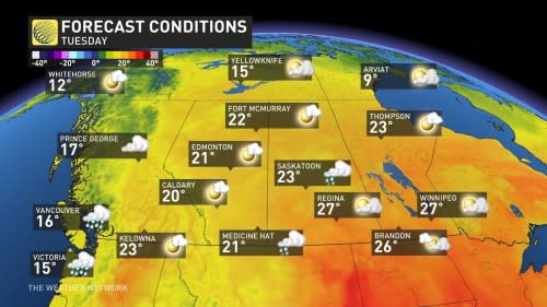
Summer-like temperatures on the eastern side of the storm will send readings as much as 9°C above seasonal on Monday and Tuesday, especially in Manitoba including Winnipeg and Dauphin.
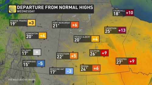
Meanwhile, cooler air filtering in on the western side of the system will keep temperatures well below seasonal across southern Alberta. Calgary and Lethbridge aren’t even expected to reach the 15-degree mark on Wednesday.
Plenty of heavy rain and embedded thunderstorms will accompany this system across the border. The greatest swath of rain will closely mirror what we saw this past week, with the heaviest totals falling from southern Alberta into central Saskatchewan.
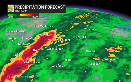
While the rain will be beneficial for northern sections of Saskatchewan still dealing with ongoing wildfires, the additional precipitation will also heighten the threat for localized flooding. Be sure to stay alert to the changing conditions and any watches and warnings that are issued in your area.