
It’s no secret that it’s been above normal this September in Ontario, but the devil is in the details, or in this case, location.
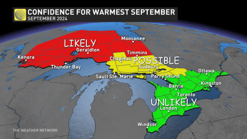
With each passing day, northern Ontario is getting closer to reaching all-time September warmth.
As of Sept. 15, the mean temperature of 18.2°C in Kenora, Ont., and 14.6°C in Timmins, Ont., is on the pace for all-time records. The mean temperature is so stunningly high in Kenora, even surpassing the average high temperature in the area (17.4°C).
RELATED: Moosonee warmer than Los Angeles as Canada feels late-summer heat

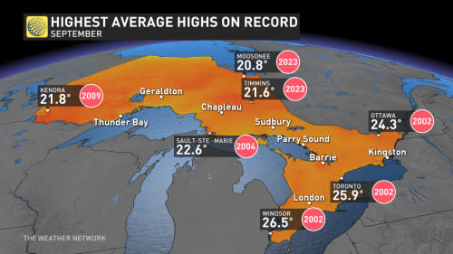
You don’t have to go too far back for record heat. Take September 2023, for example, where Moosonee and Timmins recorded their highest daily maximum average temperature at over 20°C. Both communities will challenge this once again.
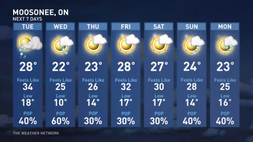
Just look at a seven-day forecast for Moosonee, and you’ll see why it’s likely it will have the warmest September on record:
Farther south, temperatures have not been as extreme, as the ridge has been strongest over northern Ontario. That will continue to be the case.
It’s still possible cities like Sudbury and Sault-Ste.-Marie record their warmest September, but the odds drastically drop off across southern Ontario.
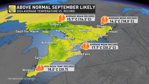
Mean temperatures this September have been within a degree of normal across the south, a far cry from September 2002 when portions of southern Ontario averaged highs exceeding 26°C.
September: A month of extremes
-
Highest temperature: Windsor, Sept. 6, 1881 (38.3°C)
-
Coldest temperature: Sault-Ste.-Marie, Sept. 30, 1945 (-8.3°C)
-
Rainiest day: Windsor, Sept. 28, 2016 (147.4 mm)
-
Strongest wind gust: Trenton, Sept. 30, 1958 (116 km/h)
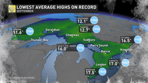
September is part of a shoulder season and has had drastic fluctuations over the decades, but the trend is clear.
The highest average highs have all been set in the 21st century, while you have to go back 50 years since the previous monthly cold record:
Long-range outlook
The September pattern wants to continually repeat itself. The jet stream has carved out a familiar pattern this month, with the tendency for troughing across the western continental U.S., pumping the ridge over Ontario and Quebec.
Another trough dives south into California later this week, reinforcing the current pattern. What’s noteworthy about this development is how far north the ridge of high pressure extends, too: Crossing Baffin Island and reaching Greenland.
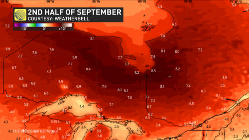
This high-pressure system is part of a larger-scale Rex block, which fuels troughing and an area of low pressure across the southeastern U.S. It’s an incredibly sticky pattern to dislodge.
In terms of precipitation trends over the next couple of weeks, there is high confidence that it will be drier than normal for most of Ontario, except for regions bordering Manitoba. There is high confidence for no rainfall near Lake Ontario over the coming week, meaning that we’re in the longest dry stretch of the entire year.