
El Niño faded earlier this year and experts expected La Niña to follow hot on its heels.
We’ve been waiting for this weather-altering pattern to show up for most of 2024—but it’s still missing. Why is La Niña running so late, and will we see the pattern develop in time for Canada’s winter season?
DON’T MISS: Will winter redeem its reputation? A sneak peek at winter 2024-25
La Niña is long expected and long overdue
The U.S. Climate Prediction Center (CPC) releases monthly outlooks to discuss the odds of the Pacific Ocean experiencing El Niño, La Niña, or “neutral” conditions. The agency’s latest outlook continued calling for a weak La Niña to develop through the upcoming winter months.
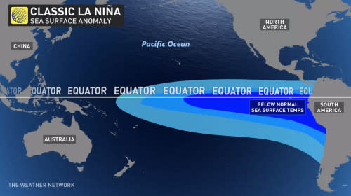
El Niño and La Niña are patterns of anomalous sea surface temperatures that have far-reaching ramifications on weather conditions around the world.
We experienced a strong El Niño from the spring of 2023 through the first couple of months of 2024, a pattern that influenced a very mild winter across much of Canada.
Experts expected that pattern to reverse course and dive into La Niña by the heart of hurricane season this summer. While the waters cooled down, we remained in neutral conditions this summer and still haven’t tipped into La Niña as of the middle of autumn.

MUST SEE: What happens when El Niño and La Niña disappear?
Where did it go? This pattern—formally known as El Niño-Southern Oscillation (ENSO)—is notoriously fickle.
Computer models are good at detecting the large-scale wind and air pressure patterns over the Pacific Ocean that dictate the timing and strength of an El Niño or La Niña. Unfortunately, there are smaller-scale factors in play that can throw a wrench in the forecast.
These small-scale factors “can’t be predicted more than a couple of weeks (at best) in advance,” Dr. Emily Becker wrote on NOAA’s ENSO Blog this month. During weak, borderline La Niña episodes like the one we may soon enter, “these small fluctuations can tip the scales one way or the other,” Dr. Becker added.
Small changes lead to big ripple effects
There are specific criteria scientists use to determine when water temperatures off the west coast of South America qualify as El Niño or La Niña.
RELATED: What is La Niña? And how does it impact global weather?
El Niño occurs when water temperatures run 0.5°C warmer than normal for about seven consecutive months, while La Niña is present when the same waters run 0.5°C cooler than normal for about the same length of time.
These changes in water temperature are sort of like a fever in the human body—they seem like tiny shifts, but they have huge implications for what happens in the atmosphere above the ocean.
Warmer and cooler waters influence large-scale wind patterns throughout the Pacific basin, with effects ranging from wildfires in Australia to raging hurricanes in the Atlantic.
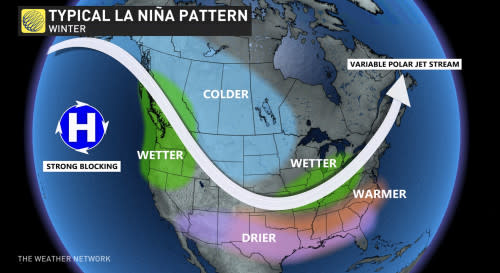
A typical La Niña winter would see upper-level winds altered in a way that brings some noticeable effects to Canada. We’d expect to see below-seasonal temperatures across Western Canada, while an active storm track would likely build over the Great Lakes and Atlantic provinces.
However, these effects are usually dulled during a weak La Niña event—and may prove even less noticeable if the upcoming event keeps defying predictions and gets delayed even longer.
Contains files from NOAA.