
Super Typhoon Yagi boomed into a Category 4 equivalent storm in the South China Sea on Thursday, making it one of the region’s strongest typhoons in recorded history. Folks across southern China, Hainan Island, and Vietnam will experience impacts from this storm with winds exceeding 160 km/h in spots.
Yagi’s location and track will eventually have an effect on Canada’s weather pattern by the middle of September.
SEPTEMBER OUTLOOK: Summer isn’t done with Canada just yet
We can’t blame the typhoon itself for the pattern change on the way. Instead, the storm’s track increases confidence in a pattern change next week.

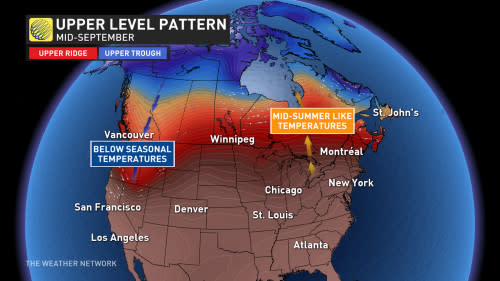
The pattern ahead will feature a ridge in Eastern Canada, covering the Great Lakes, Quebec, and parts of Atlantic Canada. Forecasters accounted for this setup in our September outlook, and now the models are starting to catch on to this change as well.
MUST SEE: Eight of the strangest hurricanes we’ve ever seen
Super Typhoon Yagi’s track increases our confidence that this scenario will likely play out. Ridging would bring above-normal temperatures and drier conditions, making for a stretch that’ll feel more like the middle of summer for many.
As a result, next weekend—the final full weekend of summer—could end up being one of the best of the entire season. Daytime highs in the middle to upper 20s, and possibly around 30 degrees in spots, are possible in southern Ontario and southern Quebec.
DON’T MISS: Rare desert rains may have stifled Atlantic hurricanes—for now
The opposite is true in the western half of the country, where upper-level troughing will signal active weather with near- to below-seasonal temperatures. British Columbia and the western Prairies may be in store for a stretch of unsettled and cooler fall weather ahead.
How long could this pattern last? It’s up in the air right now. The typhoon’s track will reinforce the incoming pattern by making it stronger and more amplified, resulting in more staying power for an extended stretch of warmth in the east. Additional factors will come into play well after the typhoon’s enhancement wanes.