
A major pattern change is underway that’ll bring a second breath of summer into Ontario heading into this new week.
This change isn’t happening quietly, though, and we’re on the lookout for downpours across the Greater Toronto Area (GTA) that could interfere with your Monday morning commute.
Prepare for travel delays across the region, and watch for ponding on roads beneath the heavier showers and thunderstorms.
DON’T MISS: Summer 2.0? Ontario heat set to return with a vengeance
An unsettled Monday ahead
Rounds of showers with embedded thunderstorms will begin developing over southern Ontario on Monday morning and continue into the afternoon hours throughout the region.

These showers and thunderstorms could be heavy at times, and the stronger storms could produce frequent lightning and locally gusty winds.
Folks travelling up along Highways 400 and 401, as well as those driving east of Toronto along the 401 and 407, will encounter a higher chance of running into these showers and thunderstorms through the day on Monday.
September Outlook: Summer isn’t done with Canada just yet
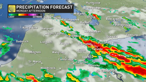
While forecasters are confident that we’ll see plenty of unsettled weather on Monday, the nature of the setup will make it tough to pinpoint where the storms will bubble up and bring heavy rainfall.
Some locations in the western GTA, including Hamilton, will see less than 5 mm of rain, while others may see up to 30 mm of rain in northern and eastern sections of the area.
Use extra caution as you head about your day on Monday, and watch out for ponding on roads beneath the heavier bouts of rainfall.
Summer 2.0 arrives by midweek
Are you ready for a second burst of summer?
A major ridge of high pressure building over the eastern half of Canada will bring Ontario a significant and long-duration spell of unseasonably warm temperatures.
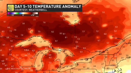
The heat builds into northern Ontario first on Tuesday, with southern Ontario following suit by Wednesday. Expect days of high temperatures in the middle to upper 20s through at least next weekend, with some communities breaching the 30-degree mark at times.
Stay with The Weather Network for all the latest on your forecast across Ontario.