
Rounds of heavy rain and thunderstorms will hit parts of the Prairies to end this week, with rain rates set to intensify through the day on Thursday.
Many parts of southern Saskatchewan, from north of Regina to Saskatoon, and along the Saskatchewan and Manitoba border, already woke up to storms early Thursday. The risk will continue as the day wears on, with the threat for heavy rain, large hail, and strong winds at times.
Visit our Complete Guide to Fall 2024 for an in-depth look at the Fall Forecast, tips to plan for it and much more!
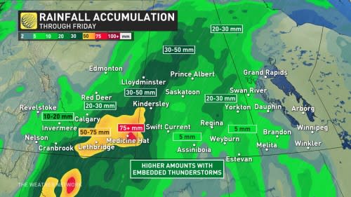
Some of the harder-hit areas along the Alberta-Saskatchewan border could see 50-75+ mm of rain fall through Friday morning.
The rain will be beneficial for northern sections of Saskatchewan still dealing with ongoing wildfires, but also heightens the threat for localized flooding. Be sure to stay alert to the changing conditions and any watches and warnings that are issued in your area.
Thursday through Friday:
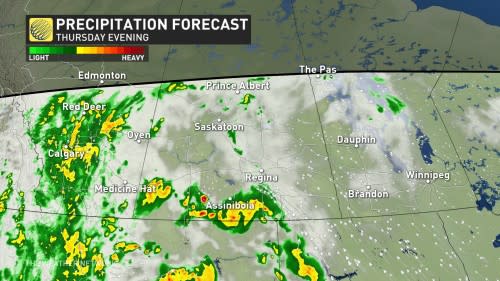
The heaviest rain and impacts will be widely felt through Thursday. That’s as a slow-moving, low-pressure system pushes north of the U.S. border, spilling heavy rain at times into the Prairie region.
The rainfall intensity will increase in several rounds.
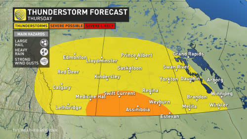
Heavy rain, and possibly severe thunderstorms, will take aim at southern Saskatchewan Thursday afternoon, lifting north into Saskatoon by the evening hours. While the the tornado risk looks to remain mostly stateside, it’ll be important to keep a close eye on extreme southern sections of Saskatchewan, and along the Montana border.
Large hail and strong winds will accompany the storm threat, in addition to the heavy rain.
Rainfall rates up to 5 mm/h are possible at times, especially in southeastern Alberta. Heavier pockets of rain could also pick up Thursday overnight and into Friday morning.
A general 10-20 mm of rain is expected for the city of Calgary, while Alberta communities bordering with Saskatchewan could see closer to 50-75+ mm. Lethbridge and Medicine Hat could both pick up some of those heavier totals.
Summer versus fall: The temperatures say it all
A large temperature contrast will span the Prairies, as well, essentially bringing two different seasons to the region.
Much of Alberta will get an early taste of fall, remaining seasonably cool for most of this week. Calgary will sit about 7°C cooler than normal.
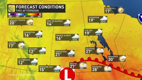
Meanwhile, parts of Manitoba will certainly enjoy a late blast of summer heat as temperatures soar close to the 30-degree mark.
For more on exactly what to expect, be sure to check out our official 2024 Fall Forecast.
Due to the track of the storms northward into Nunavut, temperatures will remain well-above normal for Manitoba and northwestern Ontario for the next 10 days.