
Heavy rain and gusty winds will end the week across Atlantic Canada after glorious late summer weather and abundant sunshine splashed through the region for several days.
Rainfall warnings are in effect for much of southern Nova Scotia, including the Halifax area, ahead of this system’s arrival. Special weather statements cover New Brunswick and PEI
September Outlook: Summer isn’t done with Canada just yet
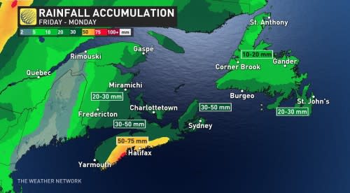
In some of the hardest-hit parts of Nova Scotia, more than 75 mm may fall, increasing the risk for localized flooding and deteriorating travel conditions. Be sure to remain alert and check the warnings in your area as the rainfall picks up by Friday night.
Heavy rain picks up Friday night through Saturday
A low-pressure system off the coast of North Carolina will move toward the Maritimes as we end the week, pushing a slug of tropical moisture into the region. We’ll see two waves of moisture associated with this system.

The first arrives in the Maritimes by Friday night and lingers into Saturday as the system slides into the region. Rainfall rates along the coast, including Halifax and Truro, could reach 5-10 mm per hour during the heaviest precipitation. In some cases, rainfall rates near 25 mm/h could fall over a 12 hour period, which could lead to flooding in vulnerable areas.
“Heavy downpours can cause flash floods and water pooling on roads,” Environment and Climate Change Canada (ECCC) said in its rainfall warning for Halifax on Friday morning. “Watch for possible washouts near rivers, creeks and culverts.”
Gusty winds of 70+ km/h are expected for portions of coastal Nova Scotia as well, making this the windiest storm we’ve seen in the region since early April. Look out for broken branches and isolated downed trees and power lines.
The second low we’ll deal with this weekend will arrive from Ontario on Sunday, clipping the southern Maritimes late in the day before moving toward Newfoundland by Monday. This wave of moisture will be less impactful and not as widespread, but it’ll bring Newfoundland its best chance for heavy rain during the event.
All told, we’re looking at widespread rainfall totals of 30-50 mm throughout much of the Maritimes, with 20-30 expected across southern Newfoundland. The heaviest rain is expected across Nova Scotia’s Atlantic coastline. 50-75 mm of rain could fall in and around Halifax, with even higher totals possible southwest from the city.
WATCH: Heavy rain targets parts of Nova Scotia, flooding a risk
There is still some uncertainty with the track of the system and just how far into southern New Brunswick the rainfall spreads, with more confidence for the heaviest rain falling across southern and eastern Nova Scotia. It will come down to how far inland the low pulls the moisture as it tracks over the Maritimes.
Regardless, many areas face a risk of flooding with heavy rain falling in a short period of time.
We’ll see the rain clear out of the Maritimes by Monday.
Be sure to check back for the latest updates across Atlantic Canada this weekend.