
An unseasonable surge of September heat building over the western Prairies will send temperatures soaring over the 30-degree mark throughout portions of Alberta and Saskatchewan, including in Calgary and Medicine Hat.
Those prone to heat-related illnesses should take care during the day to limit exposure to excessive temperatures. The good news is that we’ll feel some relief from the heat at night as low temperatures dip into the mid-teens.
DON’T MISS: SEPTEMBER 2024 OUTLOOK: Summer isn’t done with Canada just yet
Things feel more like the middle of summer than the beginning of September across the western Prairies as temperatures soar well above seasonal for the start of the month. The average high in Calgary on Sept. 1 comes in just above 20°C.
Temperatures reach record highs across Alberta and Saskatchewan
The high in Calgary on Monday topped off at an astonishing 31.1°C, making it the seventeenth-warmest September day on record. The all-time warmest temperature recorded in September was 33.3°C set back on Sept. 1, 1967.
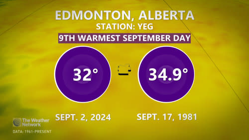
Further north in Edmonton, temperatures rose to a stifling 32°C, making it the ninth warmest September day on record as well as the warmest day since September 2022.
On Monday, the region’s warmest temperatures on Monday built over far southern Alberta and Saskatchewan, where readings reached 34°C in Drumheller, Alta., and Maple Creek, Sask. These communities therefore received the honour of being the warmest places in Canada for Sept. 2.
Temperatures will cool off in Alberta by Tuesday, although we’ll still see above-seasonal highs with readings in the mid-20s in Calgary and Edmonton will feel more comfortable than the heat we saw through Monday.
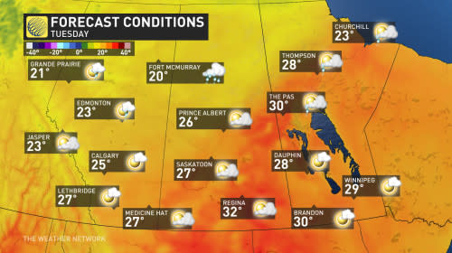
The intense heat will drift eastward on Tuesday, where temperatures could reach 32-34°C across southeastern Saskatchewan ahead of an incoming cold front.
Temperatures in Regina, Sask., could come within a couple of degrees of the city’s hottest September temperature–35.4°C, set on Sept. 4, 1998.
Thunderstorm risk comes with Tuesday heat for Saskatchewan and Manitoba
We typically start to see the risk for thunderstorms in Canada begin to wind down once we hit September, with the atmospheric instability sinking south. So it’s slightly unusual that we’re seeing enough instability present over the Prairies to trigger a severe thunderstorm risk along the Saskatchewan-Manitoba border and into northern Manitoba on Tuesday.
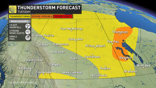
Folks in Alberta won’t be left out, as a non-severe thunderstorm risk will sit over the central and northern regions of the province, including Edmonton.
Looking ahead, this won’t be the end of the 30-degree heat for the month. Another strong ridge of high-pressure is forecast to build over Alberta and Saskatchewan by next weekend, sending temperatures back up to 10 degrees above normal.
Stay tuned to The Weather Network for more forecast updates across the Prairies.