
Change has arrived in Ontario. A raw and blustery weekend is on tap for much of southern Ontario as a potent system swings overhead.
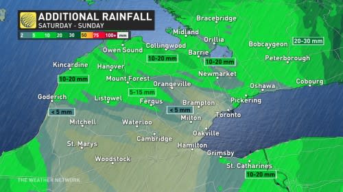
Several days of below-seasonal temperatures are on tap as gusty northwesterly winds blow through the region. We could see bands of lake-effect rain along the shores of Lake Huron and Georgian Bay.
This is also the perfect setup for waterspout formation through the weekend, so it’ll be important to remain alert to the changing conditions.
September Outlook: Summer isn’t done with Canada just yet
Saturday: Blustery with rain continuing for some
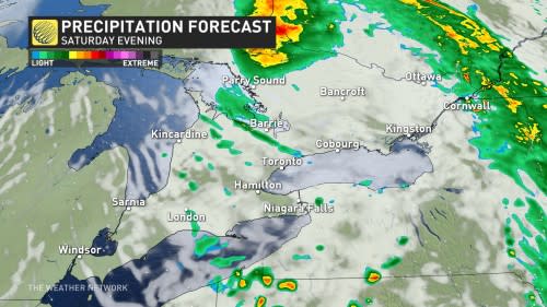
The bulk of the rain we saw on Friday will move into western Quebec by the day Saturday.
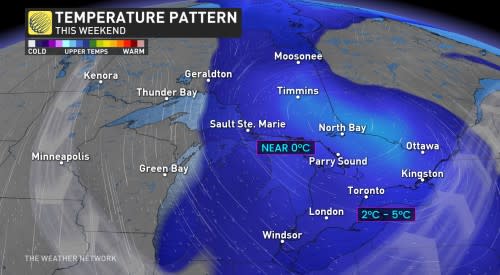
Daytime high temperatures on Saturday will come in 5 to 10 degrees colder than they were during the day Friday. Saturday’s predicted high of 15°C in Toronto is a full 8 degrees below seasonal for this point in September.
Winds gusting to 30-50 km/h alongside lingering moisture over the relatively warm lakes will kick up a risk for lake-effect rain showers across Lake Huron, Georgian Bay, and portions of the Greater Toronto Area (GTA).
Prepare to dodge the occasional shower if you have any outdoor plans.
Waterspout risk this weekend
The sharp temperature difference between the lakes below and the atmosphere high above will lead to a risk for waterspouts throughout the Great Lakes this weekend.
DON’T MISS: Ontario on waterspout watch this weekend
Conditions during the late-summer and early-fall months are prime for waterspouts as the lakes remain quite warm despite cooler air spilling into the region. This creates a temperature gradient that generates instability between the air and the lake surface, causing air to rise rapidly even outside the presence of any thunderstorms.
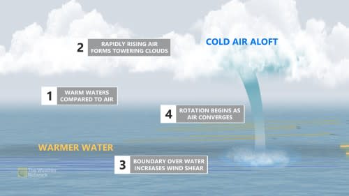
Waterspouts tend to be slow-moving or near stationary. But sometimes they can move onshore and cause minor damage or injury. It’s best to keep an eye on weather warnings in your area and adjust any outdoor plans accordingly.
Sunday: Mix of sun and clouds, chance of showers
We’ll see a mainly sunny morning across the GTA as we wrap up the weekend, though periods of clouds will roll into the region by the afternoon hours.
Scattered showers are likely throughout cottage country on Sunday, with a slight chance of a lake-effect shower inching into the GTA.
Conditions will remain blustery as northwest winds persist, with daytime high temperatures only managing to climb into the teens across the region.
Don’t write off summer just yet!
The remnants of a super typhoon in the western Pacific Ocean will boost confidence in a midsummer-like pattern draping over the eastern half of Canada by next week.
MUST SEE: A super typhoon may soon boost midsummer-like warmth in Canada
Temperatures will quickly rebound early next week as we head into an extended period of very warm and dry weather that could last well into the following week. This could end up being the most extended stretch of warm and dry weather of the entire summer.
WATCH: Waterspout potential over the Great Lakes this weekend
Thumbnail courtesy of Getty Images.