
Hurricane Beryl roared through the Caribbean in July as the earliest scale-topping Category 5 storm ever observed in the Atlantic—an apparent omen at the beginning of what experts expected to be a hyperactive, high-end hurricane season.
But save for a few odd storms, the tropics have been relatively quiet since Beryl’s deadly journey. A unique factor is driving this unexpected pause in hurricane season, and it’s not likely to last for much longer.
DON’T MISS: Hurricanes ahead? Experts expect La Niña to emerge by this fall
Where have all the hurricanes gone?
Seasonal forecasts called for a very active Atlantic hurricane season this year. Near-record sea surface temperatures across the basin, paired with other factors like a budding La Niña and an active African monsoon season, all seemed to point toward a bustling tropical basin.

Beryl was a stark example of what this season is capable of. Water temperatures remain much warmer than normal throughout the tropics—certainly warm enough to support very strong storms. But storms can only grow strong if a storm can form at all.
The main reason forecasters believe it’s been a quiet August is rather unique.
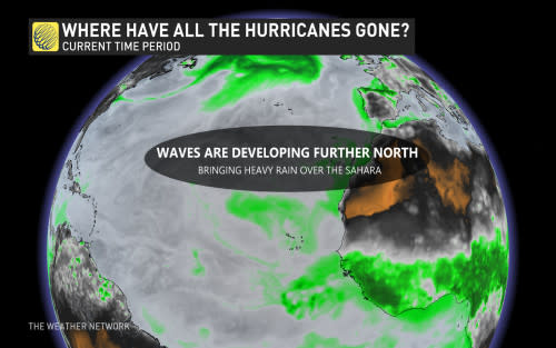
Rain falling over the Sahara Desert instead
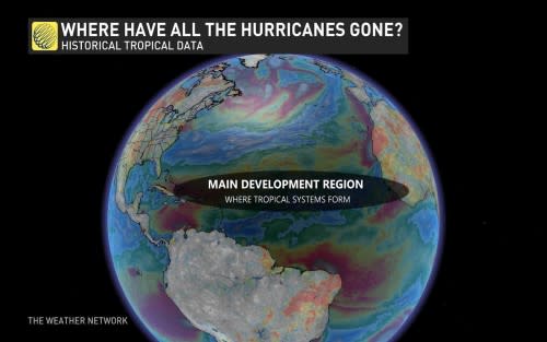
Normally, we see easterly waves—tropical disturbances—form within a broad area of low pressure known as the Intertropical Convergence Zone (ITCZ). These waves then roll off the western coast of Africa and into the tropical Atlantic Ocean where they seed the development of tropical cyclones.
RELATED: Saharan dust can make or break a monstrous Atlantic hurricane
This year, the ITCZ is sitting farther north than usual, pushing bouts of rare heavy rainfall over portions of the Sahara Desert. This precipitation could amount to an entire month’s worth of rain falling over an area that’s almost always arid, including sections of Algeria, Mali, Libya, and Niger.
Tropical waves heading farther north than usual combined with lower-than-normal instability over the tropical Atlantic Ocean have resulted in fewer opportunities for tropical waves to move over the ocean and develop into tropical storms and hurricanes.
Peak season is right around the corner
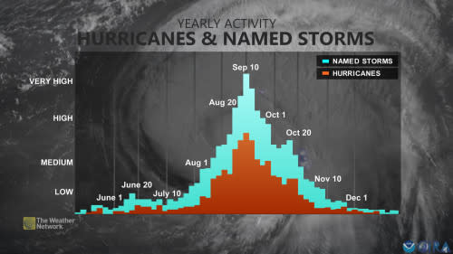
Historically, more than half of all hurricane activity in the Atlantic basin occurs after Labour Day. The climatological peak of the season occurs during the second week of September.
It’s important to remember that a quiet stretch during hurricane season doesn’t mean that the season has shut down. It only takes one storm to make for a bad season if that storm makes landfall.
MUST SEE: Hurricane forecasts are better today than ever before—here’s how
While this quiet stretch has likely cut down on the number of opportunities for storms to erupt, forecasters remain confident that we’ll see a decent number of storms over the coming weeks and months.
Hurricanes are relatively rare for a reason. It takes all the right ingredients coming together perfectly in order for a storm to develop and thrive. Many of those ingredients, such as very warm water temperatures, are in place right now.
Folks across the eastern half of Canada—even far inland in Ontario and Quebec—should prepare for potential landfalling storms over the coming weeks and months. Ensure you have an emergency kit handy long before one is ever needed.