
Expect some rumbles of thunder to end your weekend across portions of Quebec as a sharp cold front marches into the province.
Some of Sunday afternoon’s storms could turn severe across the St. Lawrence Valley. Keep a close eye on the radar as you go about your day, and stay alert for watches and warnings issued in your area.

DON’T MISS: Rare desert rains may have stifled Atlantic hurricanes—for now
Sunday’s active weather is influenced by a dazzling low-pressure system parked over Hudson Bay. This sprawling, sightly system is a force of nature, extending its influence from Canada’s Far North all the way down to Mexico.
A cold front extending off this system charged through northern Ontario during the day Saturday before eventually pushing into Quebec to end the weekend.
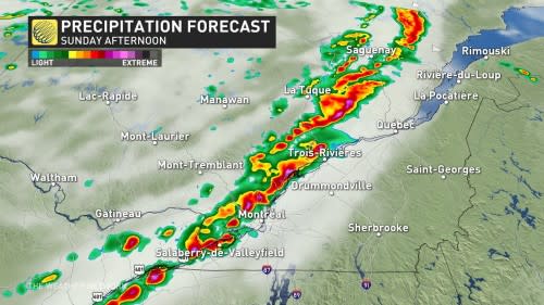
A touch of instability parked over the region combined with the sharp lift along the front will be more than enough to trigger thunderstorms throughout Quebec during the day Sunday.
The greatest severe thunderstorm risk will fall north of Montreal up the St. Lawrence during the afternoon. The strongest storms in this region could pack gusty winds, frequent lightning, and brief torrential downpours.
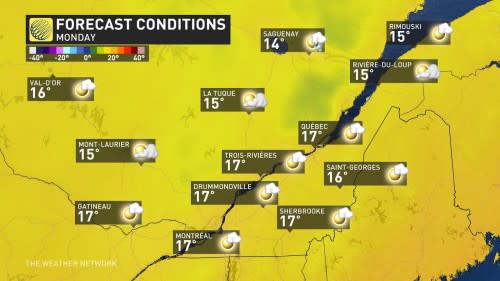
Conditions behind that cold front will bring a taste of fall to kick off September across Quebec.
Montreal’s muggy high of 26°C on Sunday will plunge ten degrees by Monday, lending a crisp edge to the air as we start our week. Farther north, temperatures will be chilly enough to call for a jacket in the late night and early morning hours.
Stay with The Weather Network for all the latest on conditions across Quebec.