
We may have had to wait until the middle of September, but we’re finally going to get some of the nicest summertime weather of the season over much of Eastern Canada.
A significant flip in the pattern will send unseasonable heat over Ontario and Quebec through the upcoming week and beyond. Temperatures will easily climb into the 20s for most communities, and a brush with the 30s can’t be ruled out for some.
But there is a potential hiccup in the upcoming pattern that forecasters are closely monitoring.
September Outlook: Summer isn’t done with Canada just yet
Big ridge brings unseasonable heat
The first flakes of the year fell over northeastern Ontario on Saturday as a chilly system swung over the Great Lakes.
That’ll be a distant memory by this week as a formidable ridge of high pressure is set to grow over the eastern half of Canada this week, part of a significant pattern change taking place across the country.
This change will be influenced by the remnants of Super Typhoon Yagi in the western Pacific Ocean, as well as a deep trough over eastern Siberia.

DON’T MISS: A super typhoon may soon boost midsummer-like warmth in Canada
These features halfway around the world will jostle the upper-level setup in such a way that we’ll see a sharp trough develop over Western Canada, which will enhance the big ridge developing back east.
Ridges foster sinking air, which heats up as it descends toward the surface. We’ll see that heat in spades through the upcoming week as temperatures will feel more like early August than the middle of September.
The heat will arrive in earnest on Wednesday as daytime highs climb into the middle to upper 20s throughout Ontario—not just southern Ontario, but also for folks up north around Sudbury and Timmins, where the warmth will begin a day earlier on Tuesday.
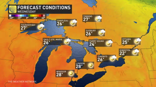
We may see high temperatures creep toward the 30-degree mark in extreme southwestern Ontario around Windsor, London, and possibly even creeping into the Greater Toronto Area at times.
While the heat will take hold of the region, it’s not going to be a humid slog like we saw so often this season. We’ll see little precipitation while this ridge is parked overhead. A relative lack of muggy humidity will make for warm, sunny days with comfortable overnight low temperatures.
A potential wildcard lurks in the Gulf
A tropical disturbance trying to get its act together in the southern Gulf of Mexico could throw a wrench in the setup by next weekend.
The U.S. National Hurricane Center (NHC) gives this disturbance a 70 percent chance of developing into a tropical storm this week as it lingers over the region’s steamy waters.

MUST SEE: Hurricane remnants can bring dangerous weather deep into Canada
Some models suggest that this system could follow upper-level patterns toward southern Ontario by next weekend, but there’s very low confidence in this scenario at this time. It’s worth watching, though, for any potential uptick in humidity or precipitation that could accompany a track toward our side of the border.
Stay with The Weather Network for the latest on your forecast across Ontario.