A topsy-turvy pattern gripping Europe brought prolific snows to higher elevations while leading to a significant flood threat across densely populated areas.
Vienna, Austria, could see its entire average summertime rainfall over the course of five days if the predictions pan out.
DON’T MISS: Rare desert rains may have stifled Atlantic hurricanes—for now

Patterns are in upheaval around the world. Eastern Canada is dealing with midsummer-like warmth, arid parts of Africa’s Sahara Desert are bathing in unusual rains, and northern Vietnam just endured its strongest typhoon on record.
The skies over Europe are no exception to this unusual spell of global weather.
A large upper-level low swinging over the continent got cut off from the jet stream this week by a large storm swirling over the Norwegian Sea and an equally steep ridge of high pressure looming over Russia.
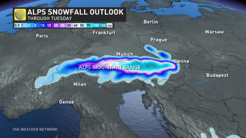

With nowhere else to go, this cutoff low had no choice but to sit and spin over Europe for days on end. A steady stream of cold air from the north, combined with ample moisture flowing in from the south, brought extensive early-season snows to the Alps.
While that’s great news for skiers, the excessive precipitation is terrible news for folks who live at lower elevations. Relentless heavy rain drenching central Europe will produce some jaw-dropping totals over the next few days.
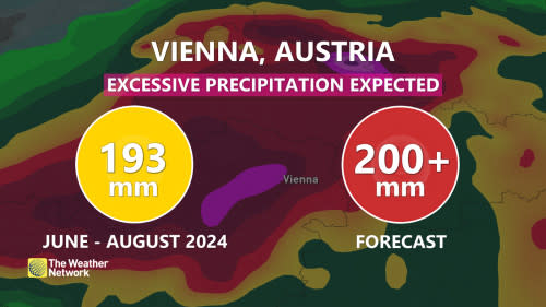

Austria’s capital of Vienna could easily see more than 200 mm of rain over just the next couple of days. To put it into perspective, that’s as much rain in a few days as Vienna saw during the entire summer. The city’s main airport recorded 193 mm of rain between June 1 and August 31.
Forecasters with Austria’s national meteorological service (ZAMG) issued red rainfall warnings for much of the country’s northeastern sections, including Vienna, as a result of this prolonged rainstorm.
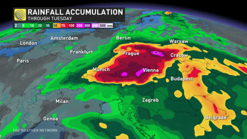

“The anticipated amounts of rainfall are expected to lead to endangerments and damages caused by mudslides, spillage inundations and flooding, as well as water ingress in homes,” ZAMG said in its warning on Friday.
This rainy, winter-like pattern should finally shake loose and bring relief to the hard-hit areas by the middle of next week.

