
After Monday saw tornado warnings issued in Manitoba and northwestern Ontario, another risk of stormy, soggy weather is in store for a good portion of the Prairies come Tuesday and beyond.
Some areas are in line to see more than 100 mm of rainfall through Thursday thanks to a potent stateside system that will slowly move eastward over the region. With the onslaught of soaking rains, the risk for localized flooding will increase.
SEE ALSO: Central Europe braces for further flooding ‘apocalypse’ as death toll rises
It will be important to pay close attention to the latest alerts in case severe weather occurs. Have a plan in place to seek safe shelter in case severe weather threatens your home, your office, or while you’re driving.
Tuesday through Thursday: Rounds of heavy rain and thunderstorms
Several days of locally heavy rainfall and thunderstorms will target eastern Alberta and western Saskatchewan, as a Montana low develops and slowly tracks northeast.

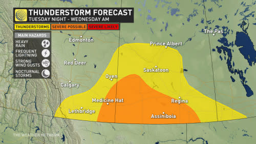
On Tuesday, thunderstorms are possible, albeit scattered in nature, across Saskatchewan. As sunset approaches, instability grows and the Montana low approaches the international border.
This is where the uncertainty lies on how strong the thunderstorms will be.
By the overnight period, however, the low becomes stronger and more organized. Expect several rain bands to pivot in from Montana.
As well, the setup will be favourable for severe thunderstorms within the rain bands, and will continue into Wednesday morning. Strong winds and heavy downpours are possible with the nocturnal storms.
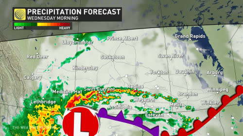
On Wednesday, the deepening low will create strong, northwesterly wind gusts across Alberta and Saskatchewan, with up to 80 km/h gusts possible.
Peak rainfall rates will occur Wednesday afternoon and evening, with the heaviest rain forecast in western Saskatchewan.
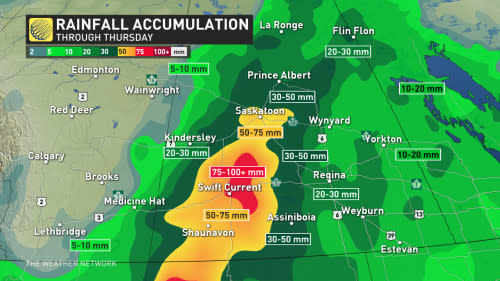
Some communities near the Alberta-Saskatchewan border could see more than 100 mm of rain through Thursday as this storm passes through the region, which heightens the risk for localized flooding.
By Thursday afternoon, the low will weaken and gradually shift north and east.
Meanwhile, cooler air filtering in on the western side of the system will keep temperatures well below seasonal across southern Alberta. Calgary and Lethbridge will struggle to climb into the mid-teens on Wednesday.
Additional showers are expected late week for parts of the region, and the potential for another system for southern Manitoba to end the weekend. Temperatures will be on the warm side of seasonal for the next week, especially for eastern parts of the region.