
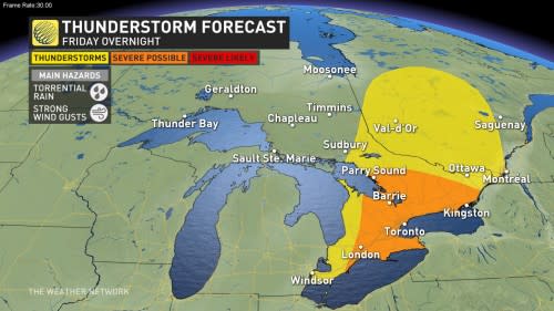
Remain alert for dangerous storms in parts of southern Ontario on Friday as a potent storm system moves into the region.
Those around Lake Huron and Georgian Bay will see the greatest threat for severe weather on Friday evening.
The severity and impacts will depend on the timing of the system so it is important to keep an eye on the radar in your area, and stay alert for additional watches and warnings that may be issued.
STAY SAFE: How severe weather alerts are issued, and potentially save lives
Evening storm risk returns to southern Ontario Friday
A low-pressure system powering across the country will make its mark on southern Ontario on Friday, just in time to kick off the long weekend.
Friday morning and early afternoon are looking nice and warm for a majority of the region, with temperatures in the middle to upper 20s. Conditions will take a turn by the evening as a series of fronts move in, bringing the potential for severe weather.

Friday afternoon will see the arrival of a warm front that’ll bring the potential for a slow-moving cluster of thunderstorms into southwestern Ontario, affecting communities from Windsor to the shores of Lake Huron.
These storms are likely to turn severe, packing a threat for strong wind gusts, large hail, and heavy rainfall. A tornado threat is possible in some of Friday afternoon’s storms. There remains some uncertainty surrounding the tornado threat, but the potential exists and it’s worth watching.
DON’T MISS: Don’t fall victim to these seven dangerous tornado myths
Storms will start to lose a bit of their edge as they make their way into the Greater Toronto Area (GTA) after sunset and into the overnight hours, with the severe weather threat transitioning over to torrential rainfall and strong wind gusts.
The atmosphere is packed with moisture and these slow-moving storms will train over some of the same communities, bringing the threat for localized flooding throughout the GTA.
Stay alert during periods of heavy rainfall. Remember: never try to drive across a flooded roadway. It’s impossible to tell how deep the water is until it’s too late.
The rain will clear out of the region in time for Saturday, bringing sunny and warm temperatures for the rest of the long weekend.
Header image submitted by Loreen.
Stay with The Weather Network for all the latest on your forecast across Ontario.